

A new interactive mapping tool predicts coastal flooding in West Maui under various scenarios of sea-level rise and wave events for residents, property owners, businesses, and state and county officials. Researchers at the Pacific Islands Ocean Observing System (PacIOOS) at the University of Hawaii at Mnoa developed the West Maui Wave-Driven Flooding with Sea Level Rise tool.
High sea levels and large swells can cause significant coastal erosion, infrastructure and property damage, and land-based sedimentation that degrades coastal water quality. In recent years, Hawaii has seen an increase in wave plus tide-driven flooding, and these events are expected to grow in number and duration due to sea-level rise and changing wave energies.
“We hope that these scenarios tailored for West Maui, along with other planning tools, will be useful to inform land use planning,” said Tara Owens, co-investigator on the grant that funded this work and extension specialist with the UH Sea Grant College Program.
Factors Influencing West Maui
The water level—and thus the risk of coastal flooding—in West Maui is influenced by several factors, including daily tidal cycles, long-term sea-level rise, moderate to large wave events, and the slowly-oscillating ocean sea level height around Maui (caused in part by El Nio). PacIOOS, based at UH Mnoa’s School of Ocean and Earth Science and Technology, developed the new West Maui Wave-Driven Flooding with Sea Level Rise tool by combining these factors and augmenting the annual high wave flooding model represented in the State of Hawaii Sea Level Rise Viewer with a next-generation modelling approach.
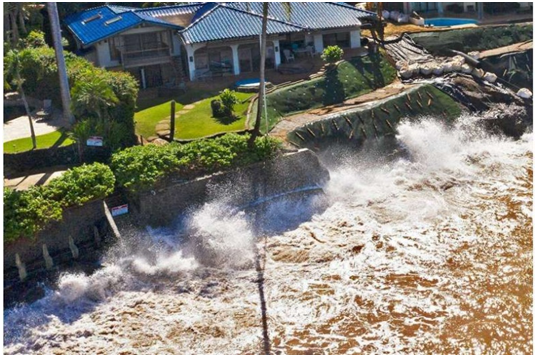
In addition to chronic coastal erosion, which causes severe property damage, wave overtopping and flooding are a major safety concern for infrastructure, particularly the Honoapiilani Highway, the main access corridor to West Maui.
“Coastal managers and planners in Hawaii rely on science-based information to support decision making,” said Jim Buika, Coastal Planner for the County of Maui. “This scenario-based tool is effective because it is both localised and simple to use. It can help us advocate for sustainable land use and environmental protection.”